Level 1 Positioning Service - List of Manufacturers, Suppliers, Companies and Products | IPROS

Level 1 Positioning Service Product List

1~10 item / All 10 items

Displayed results

Centimeter-level positioning service

Achieving high-precision positioning with an accuracy of a few centimeters using RTK technology.

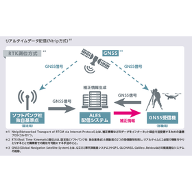
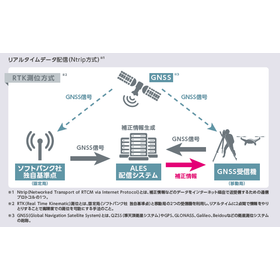
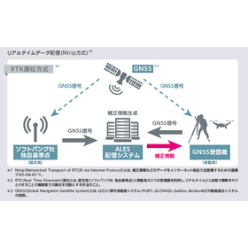
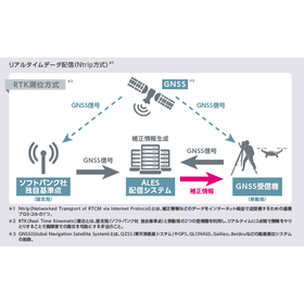
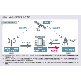
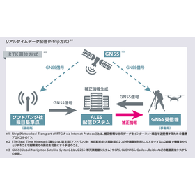
The "centimeter-level positioning service" provided by ALES is a service that delivers correction information generated by the "ALES distribution system" based on signals received by SoftBank's unique reference points (fixed stations) to GNSS receivers mounted on agricultural machinery, construction equipment, autonomous vehicles, drones, etc., via the internet (Ntrip method). It is only available to individual customers. By utilizing this correction information along with the signals received by the GNSS receiver, it is possible to perform RTK positioning with high precision, achieving accuracy within a few centimeters in real-time. Additionally, the correction information generated by the "ALES distribution system" can be linked to GNSS receivers via a smartphone.

  • Surveying
  • Level 1 Positioning Service

Added to bookmarks

Bookmarks list

Bookmark has been removed

Bookmarks list

You can't add any more bookmarks

By registering as a member, you can increase the number of bookmarks you can save and organize them with labels.

Free membership registration

Centimeter-level positioning service

Achieving high-precision positioning with an accuracy of a few centimeters using RTK technology.

The "centimeter-level positioning service" provided by ALES is a service that delivers correction information generated by the "ALES distribution system" based on signals received by SoftBank's unique reference points (fixed stations) to GNSS receivers mounted on agricultural machinery, construction equipment, autonomous vehicles, drones, etc., via the internet (Ntrip method). By utilizing this correction information along with the signals received by the GNSS receiver, it is possible to perform RTK positioning with high precision, achieving accuracy within a few centimeters in real-time. Additionally, the correction information generated by the "ALES distribution system" can be linked to GNSS receivers via a smartphone.

  • Company:ALES
  • Price:Other
  • Analysis and prediction system
  • Other measuring instruments
  • Level 1 Positioning Service

Added to bookmarks

Bookmarks list

Bookmark has been removed

Bookmarks list

You can't add any more bookmarks

By registering as a member, you can increase the number of bookmarks you can save and organize them with labels.

Free membership registration

Centimeter-level positioning service for construction sites

Improving construction site construction accuracy with RTK technology.

In the construction industry, the accurate placement and dimension management of structures significantly affect the quality and safety of the work. Particularly in situations that require precise surveying and marking, even slight errors are unacceptable. Inaccurate measurements can lead to rework and discrepancies with the design, resulting in project delays and increased costs. Our service addresses these challenges by utilizing RTK technology to provide real-time, high-precision positioning with errors of just a few centimeters. 【Application Scenarios】 - Precise surveying and marking - Guidance of heavy machinery and construction equipment - Surveying and inspection using drones 【Benefits of Implementation】 - Improved construction accuracy - Reduced project duration and costs - Enhanced safety of operations

  • Surveying
  • Level 1 Positioning Service

Added to bookmarks

Bookmarks list

Bookmark has been removed

Bookmarks list

You can't add any more bookmarks

By registering as a member, you can increase the number of bookmarks you can save and organize them with labels.

Free membership registration

Centimeter-level positioning service for agriculture

High-precision positioning with an error of a few centimeters that supports precise distribution.

In the agricultural sector, uniform and accurate application of pesticides and fertilizers is required. In particular, applying them evenly across the entire field is crucial for ensuring uniform crop growth and stabilizing yields. Improper application can lead to excessive spraying in some areas or missed spots, which can result in harvest losses and increased costs. Our "centimeter-level positioning service" utilizes RTK technology to achieve real-time, high-precision positioning with an error of just a few centimeters, supporting precise application tasks. 【Usage Scenarios】 - Navigation for precise application routes using agricultural machinery - Management of optimal application amounts for each field - Improvement of work efficiency and reduction of human errors 【Benefits of Implementation】 - Cost reduction through proper use of pesticides and fertilizers - Promotion of crop growth and stabilization of yields through uniform application - Labor-saving and improved accuracy in operations

  • Surveying
  • Level 1 Positioning Service

Added to bookmarks

Bookmarks list

Bookmark has been removed

Bookmarks list

You can't add any more bookmarks

By registering as a member, you can increase the number of bookmarks you can save and organize them with labels.

Free membership registration

Centimeter-level positioning service for drones

Support for precise drone flight with RTK technology.

In precision flying with drones, accurate positioning information is essential. Especially for applications such as aerial photography, surveying, and inspections, even a few centimeters of error may not be acceptable. Inaccurate positioning information can lead to mission failures or the need for rework. Our "centimeter-level positioning service" utilizes RTK technology to achieve high-precision positioning with an error of just a few centimeters in real-time, supporting precise drone flights. 【Use Cases】 - High-precision aerial photography - Detailed terrain surveying - Precise inspections of structures 【Benefits of Implementation】 - Increased mission success rate - Improved work efficiency - Enhanced data accuracy

  • Surveying
  • Level 1 Positioning Service

Added to bookmarks

Bookmarks list

Bookmark has been removed

Bookmarks list

You can't add any more bookmarks

By registering as a member, you can increase the number of bookmarks you can save and organize them with labels.

Free membership registration

Introduction and referral system for "centimeter-level positioning services."

Now recruiting for agents!

ALES is currently recruiting agents (referral scheme) for centimeter-level positioning services. If you are a company dealing with GPS guidance, drones, surveying equipment, etc., please feel free to contact us. For detailed inquiries, please visit here: https://ales-corp.co.jp/contact-us-all/

  • Company:ALES
  • Price:Other
  • others
  • Level 1 Positioning Service

Added to bookmarks

Bookmarks list

Bookmark has been removed

Bookmarks list

You can't add any more bookmarks

By registering as a member, you can increase the number of bookmarks you can save and organize them with labels.

Free membership registration

Trial use of "centimeter-level positioning service"

Free trial for 1 month!

You can try our centimeter-level positioning service for free for one month. If you are interested, please contact us using the link below. https://ales-corp.co.jp/contact-us-other/ Experience the high precision positioning accuracy with an error of just a few centimeters.

  • Company:ALES
  • Price:Other
  • others
  • Level 1 Positioning Service

Added to bookmarks

Bookmarks list

Bookmark has been removed

Bookmarks list

You can't add any more bookmarks

By registering as a member, you can increase the number of bookmarks you can save and organize them with labels.

Free membership registration

Pricing plans for "centimeter-level positioning services"

Two pricing plans: annual plan and monthly plan.

ALES's "Centimeter-Level Positioning Service" currently offers two pricing plans: an annual plan and a monthly plan, allowing you to choose based on your usage needs. For details on pricing, please check here: https://ales-corp.co.jp/service-payment/ We also have a pricing simulation available based on the number of months you plan to use the service, so please take a look at that as well.

  • Company:ALES
  • Price:Other
  • others
  • Level 1 Positioning Service

Added to bookmarks

Bookmarks list

Bookmark has been removed

Bookmarks list

You can't add any more bookmarks

By registering as a member, you can increase the number of bookmarks you can save and organize them with labels.

Free membership registration

Centimeter-level positioning service for surveying

High-precision positioning with an error of a few centimeters for terrain mapping.

In the surveying industry, obtaining detailed and accurate topographic data is essential for terrain mapping. Particularly, to efficiently grasp extensive terrain and create high-precision maps, it is important to minimize positional errors. Inaccurate survey data can lead to rework in design and development, as well as delays in planning. Our "centimeter-level positioning service" utilizes RTK technology to achieve high-precision positioning with errors of just a few centimeters in real-time, addressing these challenges. 【Application Scenarios】 - Extensive terrain surveying - Detailed terrain mapping - Surveying of construction sites and planned development areas 【Benefits of Implementation】 - Acquisition of high-precision topographic data - Increased efficiency in surveying operations - Reduction in data creation time

  • Surveying
  • Level 1 Positioning Service

Added to bookmarks

Bookmarks list

Bookmark has been removed

Bookmarks list

You can't add any more bookmarks

By registering as a member, you can increase the number of bookmarks you can save and organize them with labels.

Free membership registration

Centimeter-level positioning service for infrastructure inspection

Support for abnormal detection in infrastructure inspections with high-precision positioning within a few centimeters of error.

In infrastructure inspections, accurately understanding the deterioration and abnormal areas of equipment is essential for ensuring safety and improving maintenance efficiency. Particularly, to grasp the detailed condition of extensive structures and not miss subtle changes, data collection based on high-precision location information is required. Our centimeter-level positioning service addresses these challenges by providing real-time, high-precision positioning with an error of just a few centimeters, supporting the detection of anomalies in infrastructure. 【Usage Scenarios】 - Inspection of structures such as bridges, tunnels, and roads - Patrol of infrastructure facilities like power lines and pipelines - Wide-area infrastructure condition assessment using drones - Provision of high-precision location information for inspection data 【Benefits of Implementation】 - Improved accuracy in identifying abnormal areas - Increased efficiency and speed of inspection work - Development of accurate maintenance plans based on detailed data - Enhanced safety and reduced accident risks

  • Surveying
  • Level 1 Positioning Service

Added to bookmarks

Bookmarks list

Bookmark has been removed

Bookmarks list

You can't add any more bookmarks

By registering as a member, you can increase the number of bookmarks you can save and organize them with labels.

Free membership registration